Best Winter Hikes in San Diego County
A San Diego Hiking Guide
Last Updated: 1/23/2026
If you’re looking for the best winter hikes in San Diego County, you’re in the right place. From coastal trails with ocean views to mountain and desert hikes that are way more enjoyable in cooler temps, San Diego County has no shortage of incredible winter hiking options. This guide breaks down some of the best trails to explore when summer heat dies down and hiking season is at its peak.

If you want more a detailed trail breakdown, I also have full guides on Annie’s Canyon, a unique slot canyon along a lagoon, and Potato Chip Rock, one of the most iconic summit hikes in San Diego.
– Annie’s Canyon Hike
– Potato Chip Rock Hike in San Diego
Some of the links on this site are affiliate links, meaning I may earn a small commission if you make a purchase through them, at no additional cost to you. Thank you for your support!
Overview of Hiking in San Diego County
San Diego County was built for hikers- it offers a wide range of trails that has something for all hiking skill levels and interests. San Diego’s desert, particularly the Anza-Borrego Desert State Park, features miles of trails and stunning landscapes, including oases replete with palm trees and even slot canyons!
If you want a slot canyon along a coastal lagoon, make sure you check out Annie’s Canyon!
Winter offers comfortable temperatures to experience the magic of the desert, making it one of the best places to hike this winter.
If you’re more of a beach person, there’s plenty of that as well. Cooler temps reduces the crowds on popular trails such as Torrey Pines State Natural Reserve, allowing you a peaceful experience in an otherwise busy area.
With over 1,000 miles of hiking trails, San Diego County is a haven for outdoor enthusiasts, offering breathtaking views, diverse wildlife, and a chance to connect with nature.

Best Time to Hike in San Diego County
San Diego’s mild climate makes it an ideal hiking destination year-round. However, the best time to hike in San Diego depends on your personal preference and the region you plan to explore.
Winter (November to February) is the best time to hike in San Diego’s desert regions, such as Anza-Borrego Desert State Park, as the temperatures are mild and wildflowers are in bloom.
Spring (March to June) is ideal for hiking in San Diego’s mountains, such as Cuyamaca Rancho State Park, as the weather is mild, the snow has melted, and wildflowers are in full bloom. Just make sure you double check the weather, as spring does tend to be rainy!
Summer (July to September) is ideal for a coastal hike, such as Annie’s Canyon, Torrey Pines State Beach, and Sunset Cliffs.
Autumn (September to November) is a great time to hike in San Diego’s arid mountains and coastal areas, with my personal favorite fall hike being Mission Trails Regional Park.
If you’re planning winter hikes in San Diego, layering still matters—especially in the mountains and desert. I break it all down in my What to Wear Winter Hiking guide and include everything you need in my free Winter Hiking Checklist.
Top 5 Winter Hikes in San Diego County
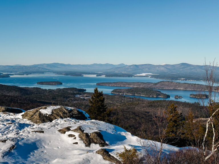
1. Cowles Mountain

Distance
3 MILES ROUND TRIP
Duration
2 HOURS
Elevation Gain
900 FEET
Difficulty
MODERATE
Cowles Mountain is the highest point in the city of San Diego and offers incredible views of downtown San Diego, the Pacific Ocean, and even into Mexico on a clear day. This is a short trail that offers beautiful views, making it ideal for a short but fun hike.
There are a couple things to note when planning this hike:
- Wear good quality hiking boots with excellent traction and ankle support. There is loose gravel and scree that can become slippery! Make sure you check out my Hiking Boot Guide for Women if you’re shopping for a reliable pair.
- Expect lots of crowds on the weekends. Parking isn’t guaranteed, so make sure you plan ahead and get there early.
- There is NO SHADE on this trail- so I would suggest avoiding this entirely in the summer or going in the early morning or late evening.
- Although there are switchbacks, the trail is fairly steep all the way to top. Take breaks as you need them.
- This is a fragile ecological area, so make sure you stay on trail as best you can.
Hiking Details
There are two trails up the mountain, but I suggest the east side approach as it’s not as busy, and the spectacular views as you hike up will keep the hike interesting. To access the trailhead, drive to Big Rock Park, where you can access free parking along the street. You’ll follow Big Rock Trail for half the hike, avoiding a left turn for the Mesa Trail. This intersection is well marked, but always check your navigation system! I usually just use AllTrails for an urban hike.
Once you get to Cowles Access Road, take a right and follow the wide dirt road to the summit. Watch out for and avoid the small side trails shooting off as you go up; only the road will bring you to the summit! Luckily Cowles Access Road is easy to follow. Once you reach the summit, you can enjoy 360 spectacular views of San Diego! Follow the trail back down in reverse to return to your car, or enjoy more trails in the Mission Trails Regional Park! There are so many awesome hikes in this area, it’s such a gem.
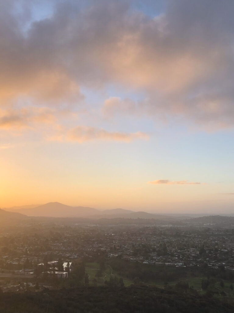
2.Mother Miguel
Distance
4.5 MILES ROUND TRIP
Duration
2.5 HOURS
elevation gain
1,040 FT
difficulty
MODERATE
Mother Miguel is a more mild version of Cowles that offers similar views, although you can’t see into San Diego as well. It does however offer stunning vistas of the mountains of San Diego and is one of my favorite locations to see a sunset.
There are a couple things to note when planning this hike:
- Expect lots of crowds on the weekends. Parking isn’t guaranteed, so make sure you plan ahead and get there early.
- There is NO SHADE on this trail- so I would suggest avoiding this entirely in the summer or going in the early morning or late evening.
- Although there are switchbacks, the trail is fairly steep all the way to top. Take breaks as you need them.
- This is a fragile ecological area, so make sure you stay on trail as best you can.
- Because this trail is exposed and steep, make sure you’re packed properly- especially with extra water and sun protection. I cover everything you need in my What to Pack for a Day Hike guide.
Hiking Details
The trail begins at the end of the cul-de-sac on Paseo Veracruz in Chula Vista, right next to someone’s house. It’s an awkward start, but you can’t miss the trailhead and there is free on-street parking. After a short distance from the cul-de-sac, you’ll walk past a metal gate where the trail begins.
I suggest you take the narrower trail to the left of the entrance, leading you beneath power lines and quickly merging with another trail from the left. From here, the way up does get confusing, as there are many options as you go along. Using an AllTrails map for this is ideal to avoid getting lost!
I suggest staying with the switchbacks, as they’re easier on the body and helps prevent rapid trail erosion. The trail will continue to rise as you make your way to the summit. Once there, you can enjoy the views and the fruits of your labor! Take the same path back down to your car.
3.Carlsbad Sea Wall Trail

DISTANCE
1.5 MILES
Duration
1 HOUR – 30 MINS
ELEVATION GAIN
26 FEET
DIFFICULTY
EASY
Carlsbad Seawall offers a more mellow experience that is more akin to walking- but if you want to have a chill day on the beach without having to deal with the sand, then this paved area is perfect! Grab a friend, grab a coffee, and have yourself a day.
The Carlsbad Sea Wall is a paved trail that has an upper portion along the famed Pacific Highway, where there’s free parking.
The paved lower portion runs along the beautiful Carlsbad beach, allowing you to enjoy the sun reflecting off the Pacific Ocean without having to deal with the dreaded sand.
Hiking Details
On average the trail is about 6 feet wide, with sections that open up to the beach so you can access the ocean, should you so desire. There is also a public restroom at the north end of the trail, which makes for a convenient day trip.
Dogs are not allowed on the beach side of the walk, but they can be leashed along the upper part that runs along the Pacific Highway.
Along the bottom path are adorable squirrels that provide fun entertainment*, and there are surfers to watch! This is a great winter hike that is convenient and accessible to most.

4. Torrey Pines State Natural Reserve

distance
2.5 MILES
Duration
1-2 HOURS
elevation gain
357 FT
difficulty
EASY
Torrey Pines is a true treasure in San Diego. This state reserve offers hiking trails on top of an eroded cliffside along the ocean, dotted with the endemic Torrey Pines, one of the most rare pine trees on Earth. Hikes in this area are interwoven and chaotic, but it’s truly an ecological treasure and a peaceful experience.
Hiking Details
To access the main parts of the state park, exit State Highway 21 towards the Torrey Pines State Reserve and pay your fee at the cabin. I suggest parking at the lot to the left of the entrance- you have to go up the steep road to access the tops of the cliffs, that way you can finish along the beach.
Once you go up the paved road the first trail you come across is the Guy Fleming Trail. If you keep going up the road you’ll come across another parking lot and some bathroom, along with the Beach Trail and Razor Point trail.
Here are some of my favorite trails:
Guy Fleming Trail
The first trail you’ll encounter is the Guy Fleming Trail. It’s a beautiful trail that winds through a stand of Torrey Pines and unique sandstone features.
Razor Point Trail
Starting up on the cliffs, Razor Point winds along the eroded badlands that also provides dramatic ocean views and scattered Torrey Pines.
The Beach Trail
Probably one of the harder trails at Torrey Pines, this is a path that descends 350 feet to the beach, with the final descent being quite narrow and steep.


5. Big Laguna

DISTANCE
10.2 MILES
Duration
4-5 HOURS
elevation gain
1,164 FT
difficulty
MODERATE
Perfect for a fall or spring hike, the Big Laguna Loop takes you along the forested edge or meadows featuring small ponds and wildlife. A short section takes you along the Pacific Crest Trail, giving you a birds eye view of the Anza Borrego desert below. I love this hike for the afternoons I want a longer adventure but don’t want to work too hard.
Things to note when planning this hike:
- Expect lots of crowds on the weekends. Parking isn’t guaranteed, so make sure you plan ahead and get there early.
- This is a fragile ecological area, so make sure you stay on trail.
- Because this trail is exposed and steep, make sure you’re packed properly- especially with extra water and sun protection. I cover everything you need in my What to Pack for a Day Hike guide.
- The PCT section of this hike has lots of scree and loose rocks, so make sure you wear proper hiking boots. Make sure you check out my Hiking Boot Guide for Women if you’re shopping for a reliable pair.
- You are required to display an adventure pass on your windshield while parked, which you can purchase online and printed out. I found this Reddit article helpful.
Hiking Details
The PCT section of the hike is the hardest and provides almost no shade, so I highly recommend that you hike this trail clockwise by beginning with the PCT. That way you don’t end up hiking in direct sunlight with no shade after hiking 8 miles… I have made this mistake before!
About 4 miles in the PCT will intersect with the Big Laguna Trail, where you’ll go somewhat straight and cross the road. Once you’re on the Big Laguna Trail the trail becomes shady and wooded, and at that point it becomes mostly flat.
Enjoy the views of meadows, trees, and even cows as you experience the Cleveland National Forest.

What to Pack for a Day Hike
Even on a short hike, you want to make sure that you have the right gear to keep you safe and comfortable.
For a full breakdown of what to pack, check out this blog post: What to Pack for a Day Hike- the Essentials
At a minimum, you should pack the essential ten:
- Navigation: a map & compass or a GPS
- Illumination: a headlamp
- Sun protection: sunglasses, sunblock, and a hat
- Emergency shelter
- Insulation: wool beanie, midweight layer
- Firestarter: waterproof matches
- Gear repair kit: duct tape, sewing kit
- Extra water
- Extra food
In addition, you want to make sure that you pack:
- Extra socks
- Snacks
- At least 2 liters of water
What to Wear on a Winter Hike
A winter hike in San Diego is a little different from hiking in the snow, but you still want to make sure that you wear the right layers to the trail. Note that the mountains of San Diego get snow and are often quite cold, so keep an eye on the weather.You should wear a base layer, moisture-wicking materials, and a weatherproof shell.
It’s also a good idea to wear wool socks and a good pair of hiking boots, and pack extra water and snacks. To make it easier to pack for a hike, I made a complete packing list so you don’t have to worry about forgetting anything. Download below!
I also offer a full breakdown of what to wear winter hiking here: What to Wear Winter Hiking
Pin for Later!